Information for Debaters
THE STONY LAKE HERITAGE FOUNDATION
STONY vs. STONEY: LET’S DEBATE IT!
The Pavilion, July 19, 2016 2:00 p.m.
Selected background materials
(prepared by Blair Mackenzie, updated with additional reference material
located following the debate)
1. Early references
1. In 1835 the Federal government commissioned N. H. Baird to carry out a
survey of the waterways from Rice Lake to Lake Simcoe, with a view to
establishing a route for what would eventually be the Trent Canal system.
I have not seen a copy of this survey, but the references I have seen to it are
consistent that in it, Mr Baird referenced ‘Stoney Lake’.
2. In 1836, “Backwoods of Canada” by Catharine Parr Traill was published. On
page 147, a map appears which references ‘Stoney Lake’. A scanned copy of the
original 1836 edition is available online at Library and Archives Canada
(collectionsccanada.gc.ca). One cannot be sure whether the ‘Stoney’ spelling
reflected a choice made by the author, or her publisher, or both.
3. In 1848 Sanford Fleming (later Sir Sanford Fleming) prepared a map of what
is today Peterborough County and more. In it we find ‘Salmon Trout Lake’ and
‘Upper Stoney Lake’.
4. In 1852, “Roughing it in the Bush” by Suzanna Moodie was published.
Suzanna Moodie was the sister of Catherine Parr Traill. In Suzanna Moodie’s
book, chapter 5 is devoted to ‘A Trip to Stony Lake’. A scanned copy of most of
the original 1852 edition is available online at Library and Archives Canada
(collectionsccanada.gc.ca). Here as well, one cannot be sure whether the use of
‘Stony’ reflected a choice made by the author, or by the publisher, or both.
5. In 1853, “27 Years in Canada West” was published by Samuel Strickland.
Samuel Strickland was the brother of Catherine Parr Traill and Suzanna
Moodie, and a leading citizen of Lakefield. In chapter XIV the book references
‘Stony Lake’. A scanned cop of the original 1853 edition is available online at
Library and Archives Canada (collectionscanada.gc.ca).
6. In 1873, Ontario deputy surveyor general Thomas Devine issued a map
referencing Stony Lake.
7. In 1882, “Picturesque Canada” was published. This was a scholarly work,
edited by G.M. Grant, then the Principal of Queen’s College, Kingston. One of
the many illustrations in it is of ‘Stony Lake, near Peterborough’ and there are
multiple references in the text to Stony Lake.
8. In 1883, George M. Roger and E. B. Edwards, both Peterborough lawyers,
jointly purchased Island 18 (i.e. Juniper Island) from the Crown. The deed
referred to Island 18 as located in ‘Salmon Trout Lake or Stoney Lake’.
9. During the period that surveying and construction work on the Trent-Severn
Waterway took place in the Buckhorn, Burleigh Falls and Fenelon Falls sector
(roughly 1882-1887), there were multiple references to ‘Stony Lake’ in the
Parliamentary record (Hansard and supplementary estimates) but none that I
could find to Stoney Lake.
10. In 1907, Messers Roger and Edwards conveyed the lands that are today
owned by the ASLC to James Acton, Henry Sutherland and Samuel Henderson
without charge, in trust for a corporation to be incorporated as “The Stony
Lake Cottagers Association”. The deed references ‘that part of the Island in
Stony Lake known as Juniper Island…opposite the Township of Dummer in
Stony Lake according to the Map or Plan of The Otonabee River and its Lakes
prepared by J. J. Hazlett of record in the Department of Indian Affairs…’
It can be argued from the above and other early references that the Stoney
spelling predominated in the years roughly before 1850 and was gradually
displaced thereafter by the Stony spelling.
2. The official name of the Lake
Q: Does the Lake have an official or government-approved name?
A: Yes: Stony Lake. This name officially applies to all of what is locally called
Clear Lake, Stony Lake or Stoney Lake, and Upper Stoney Lake.
Official Canadian place names are determined by government. In Ontario,
official place names are determined by the Ontario Geographic Place Names
Board, subject to the approval of the Minister of Natural Resources. The
Ontario registry of place names is available online at the Government of
Ontario / Ministry of Natural Resources website. Board decisions are used by
government ministries and agencies in the preparation of maps and other
documents. The Canadian Permanent Committee on Geographical Names
accepts the decisions of the Provinces and enters these into the Gazetteer of
Canada. The official name (i.e. Stony Lake) was adopted by the Place Names
Board in 1953. Prior to that time, the lake did not have an officially sanctioned
name.
Q: What if anything compels individuals, businesses or other non-
government entities to use officially approved place names or officially
approved spellings?
A: In principle, nothing compels individuals to use officially approved place
names. (Certain specific contexts, such as identifying where you live on a
passport application, might require otherwise.) It would be routine for an
individual, if asked where he or she lives, to say that he or she lives in (e.g.)
Rockliffe Park, rather than Ottawa, or The Beach or The Beaches, rather than
Toronto. Neither Rockliffe Park nor The Beach / The Beaches has any official
status in Ontario as a place name. Curve Lake First Nation prefers to refer to
Petroglyphs Provincial Park as Kinomaage-Waapkong (“The Rocks That
Teach”). The same principle would hold true for officially adopted spellings.
Q: Was the Ontario Geographic Place Names Board justified in choosing
Stony Lake as the official name?
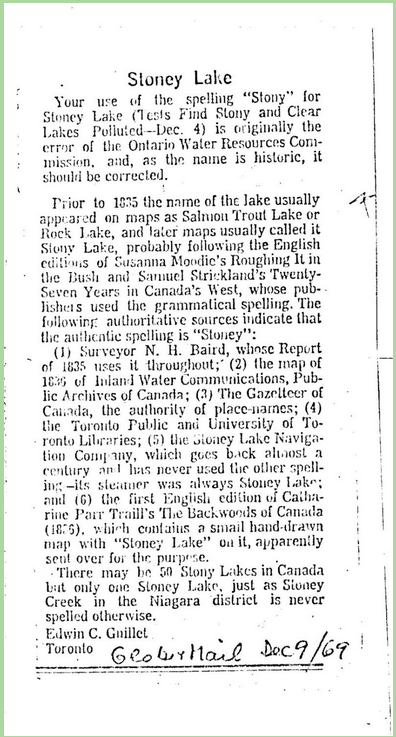
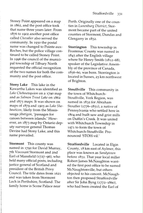
A: It depends on who you consult. Edwin Guillet believed it to be a mistake.
Alan Rayburn has a somewhat different take on it:
EDWIN GUILLET
The distinguished historian Edwin Guillet was the author of The Valley of the
Trent (1957) along with many other works. In 1969 he wrote a letter to the
editor of the Globe & Mail as follows:


